When I am planning on traveling to a specific area, the first thing I do is get out the highway and railroad maps that are relevant to the area I’m interested in. I prefer to take a “top-down” approach when determining where I want to go railfanning.
The first book I turn to is the classic Rand McNally Road Atlas to get a general look at the area. Since I prefer to drive, rather than fly, I get a lot of use out of the two-page spread that shows the entire country. Once I get a good look at the area, it’s time to get out the U.S. Railroad Traffic Atlas that was produced by Harry Ladd. The data is dated, but it still holds pretty true to get a general sense of the traffic density in the area. Sometimes I want to find the busiest main line, and other times, I want to explore a lightly used branch line. This interesting book of railroad maps also shows the locations of engine terminals at the time.
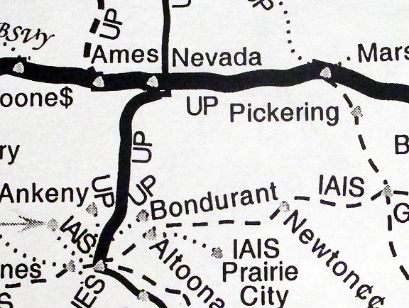
Detail of U.S. Railroad Traffic Atlas, copyright Harry Ladd
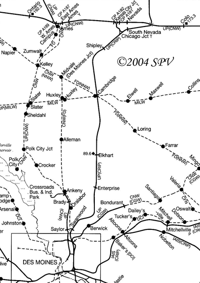
Detail of the same general area from the SPV Comprehensive Railroad Atlas of North America for comparison
After getting the general layout, it’s time to open up the DeLorme Atlas & Gazetteer for the state that I’m interested in. This is a book of maps that gives great detail for both roads and railroads. In cities, you might be better using the Rand McNally Road Atlas (or a state-issued map with urban blow-ups), but for all other places, you can’t beat the DeLorme Gazetteer to find and follow the railroads. It shows lots of smaller roads, and many of them are named, although some just show a numerical designation that matches up with the small white plates you see along the road. This is a tremendous research tool, as it shows both a detailed look at both the roads and the railroads together. It is also an invaluable aid in railroad photography, as you can see which way the roads and railroads are oriented in order to get the optimum sun angle. While giving this a good looking over, I might find some interesting rail lines that I am unfamiliar with. Now it’s time to get out the book of railroad maps published by SPV, their Comprehensive Railroad Atlas of North America, that is split up into different states and regions. Not only does it show great detail, but it also shows trackage rights and previous owners. If I find an interesting line, I will go back to the Railroad Traffic Atlas to get an idea of whether it still sees service, keeping in mind that the information is dated. The SPV atlas might even show some other branches and abandoned lines that I might want to explore, so it’s back to the Gazetteer to see what I can follow.
I’ll admit that I am a big fan and user of maps of all kinds, and using this combination of railroad maps and road atlases has allowed me not only to get some great photos at locations that I would have otherwise never found, they have been invaluable in doing railroad archaeology, where I’ve been able to trace where the track used to be. I’m also able to use them to add locations to older slides that I’ve taken and didn’t write the location on the mount. By looking at the other slides in sequence and figuring out generally where I have been, I can use these railroad maps to pin down the general location and then zero in on the exact location using the DeLorme Gazetteer for that state.